Roopak Goswami
Guwahati, Oct 9: Which are those elevations in Meghalaya which experience frequent landslides, leading to significant loss of life and property which people should avoid?
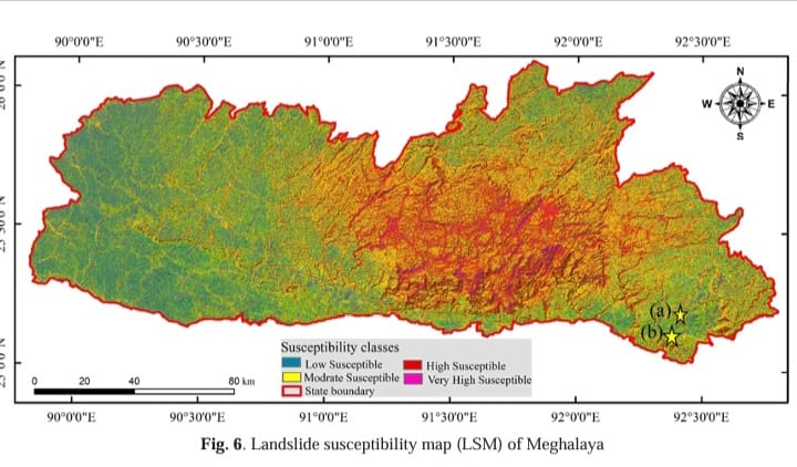
A detailed Landslide Susceptibility Map (LSM) for Meghalaya, utilizing advanced remote sensing and Geographic Information System (GIS) techniques has been developed by researchers Badavath Naveen and Smrutirekha Sahoo of Civil Engineering Department from the National Institute of Technology, Shillong which identifies high-risk zones and provides critical insights into landslide prediction and prevention for the region. The study was published in the recent issue of Journal of Geological Society of India.
Landslides in Meghalaya have significant impacts on fatalities, damage to infrastructure, displacement of communities, environmental degradation, economic consequences, disruption of services, and long-term challenges. Landslide prediction evaluation is gaining global attention and landslide prediction mapping is important for assessing and managing landslide risks and facilitating effective risk reduction strategies.
According to the study, areas with elevations above 1,400 meters are particularly vulnerable to landslides in Meghalaya. These higher elevation zones, especially in the central, southern, and southeastern parts of the state, including the Khasi Hills, are dominated by loose and unstable materials, which significantly increase the risk of slope instability.
In general, the probability of instability is low in regions with low slope inclination. “This is because there is a higher factor of safety because the resisting forces operating on the slope are greater than the driving forces. On the other hand, steep slopes are more prone to landslides due to the dominance of driving forces over the resisting forces” , the study says.
It was found that the Meghalaya region with a slope angle greater than 40 degrees had the highest probability of landslide occurrence. These steep slopes are mostly found in the area’s central and southern regions, which are known to have a higher risk of landslides.
According to a 2012 Geological Survey of India (GSI) report, the state suffers an average of 30 landslides annually. This study aims to mitigate these risks by mapping vulnerable areas and providing accurate predictions based on 15 key factors, including slope, rainfall, and distance from roads and streams.
Using the Analytical Hierarchy Process (AHP) method, the researchers analyzed over 380 landslide events and produced a susceptibility map dividing the region into four categories: low, moderate, high, and very high susceptibility. The results showed that 20% of the area falls under high susceptibility, while 4% is classified as very high. These high-risk zones align closely with previous landslide occurrences, confirming the map’s reliability for future planning.
AHP method is a semi-quantitative approach that assigns weights to each landslide-triggering factor. This technique allows for a systematic and data-driven analysis, making the susceptibility map more reliable and precise.
The study identified that the central, southern, and southeastern parts of Meghalaya are highly susceptible to landslides. Specifically, regions in the Khasi Hills have the highest concentration of very high susceptibility zones. Other areas, such as parts of the Jaintia Hills and Garo Hills, also show high susceptibility, although to a lesser extent.
In total, about 24% of the study area is classified as high to very high in terms of landslide risk, with more than 65% of these highly vulnerable zones concentrated in the Khasi Hills region. Notably, a significant number of landslides in the study area were observed along the NH-6 road.
The study specifically validates its results with recent landslide events in Meghalaya, such as those near the Sonapur tunnel and Lumshnong toll plaza. These real-life validations provide further evidence of the map’s accuracy.
The study utilizes Sentinel-2 satellite data for accurate Land Use Land Cover (LULC) classification and integrates this with landslide susceptibility mapping. This enables a finer classification of terrain and vegetation, enhancing the accuracy of the predictions.
The map is validated not only through traditional field data but also with Receiver Operating Characteristics (ROC) techniques, which quantify the model’s prediction accuracy. The study achieves a 79.7% success rate and 78% validation rate, indicating high reliability.
The researchers say the study is likely to contribute to better assessing and managing landslide risks, ensuring the development of more effective strategies for mitigating the adverse effects of landslides in
the region and improving land-use policies in the region.


