

Shillong, April 20: A new scientific study has revealed that Meghalaya faces a very high risk of powerful earthquakes, with a greater than 99% chance of a magnitude 7 or higher quake striking the region within the next 100 years.

The research, conducted by scientists Aakash Kumar, Needhi Kotoky from the National Institute of Technology, Meghalaya and Shivang Shekhar from IIT Mandi, analysed over 160 years of earthquake data across a 350 km radius surrounding Shillong. The findings are an urgent call for revising local building codes, updating infrastructure, and enhancing disaster preparedness in the state.
While several seismic hazard studies have been conducted in the various regions of NE India, a detailed and comprehensive seismic hazard study focusing on Meghalaya state is lacking. Given the rapidly increasing population and unplanned urban development in this state, it has become imperative to conduct thorough seismic hazard analysis encompassing the entire Meghalaya state.
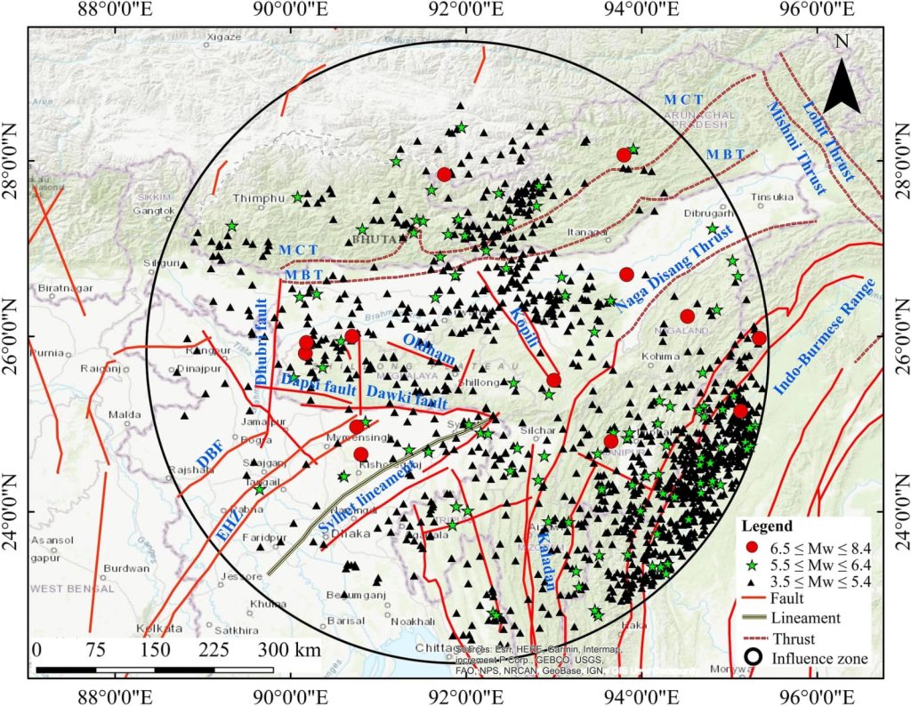
The Shillong Plateau is a complex tectonic and geological feature that lies beneath the Burmese Plate to the southeast and the Tibetan Plate to the north, and it is combined with shears and thrusts along the plate boundaries. At the base of the Shillong Plateau, foothills and traces have formed.
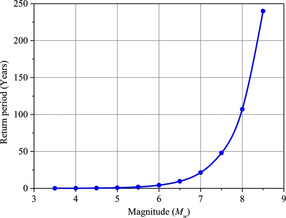
“On average, strong earthquakes could occur here every 21 years,” says Aakash Kumar, lead researcher. “This frequency highlights the pressing need for safer construction and planning, especially in urban areas like Shillong.”
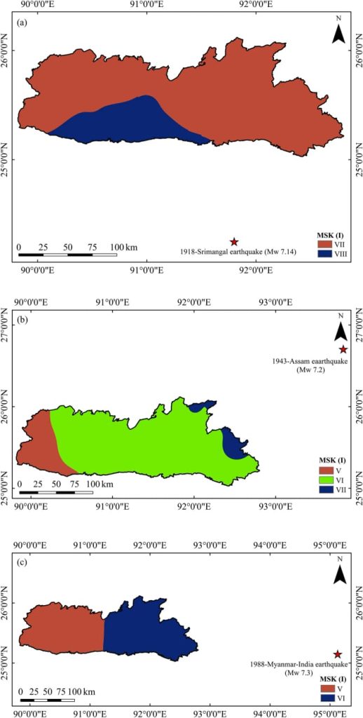
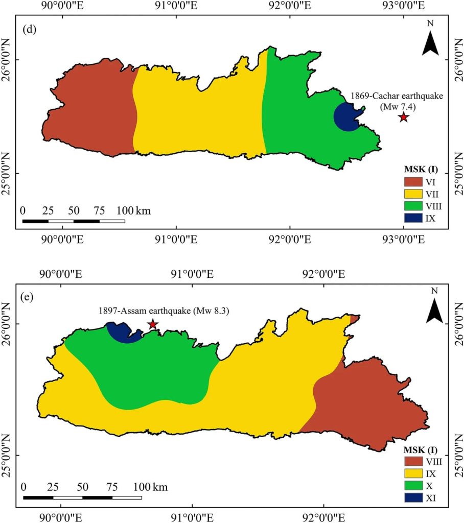
Using modern scientific tools and historical records, the team created detailed seismic hazard maps identifying areas in Meghalaya most vulnerable to ground shaking. They also produced a seismotectonic map that shows active fault lines under the surface—such as the Dauki Fault and the Oldham Fault—which are driving the region’s high seismicity.
“Key districts like Shillong, Nongstoin, Ri-Bhoi, and parts of West Khasi Hills fall in high-risk zones, where the risk of damage is extreme due to proximity to major tectonic faults”, Kumar says.
“If a quake similar to the 1897 Assam earthquake were to recur,” Kumar explains, “our maps show that regions around the Shillong Plateau could experience Intensity XI on the MSK scale—capable of causing extreme structural damage.”
Urban Vulnerability Growing
As Meghalaya develops rapidly, the authors warn that many structures, especially in older parts of Shillong, may not be able to withstand strong tremors. Ageing buildings, increasing population density, and the lack of updated seismic zoning add to the vulnerability.
“Local governments can use our seismotectonic and intensity maps to identify zones of higher seismic vulnerability and restrict or guide construction accordingly,” Aakash says.

To address this, the researchers propose using their findings to revise India’s seismic zoning maps and update the IS codes that guide construction. The current zoning, they say, doesn’t reflect the finer details of risk across different districts of Meghalaya.
What’s Next? Community Involvement
The team also plans to involve the public by collecting data on buildings across the state to assess structural vulnerability. This initiative could help identify weak spots and guide retrofitting and reinforcement efforts in schools, hospitals, and homes.
A Call to Action
This study offers crucial, science-backed information for government agencies, urban planners, engineers, and citizens. It serves as a roadmap to build a more earthquake-resilient Meghalaya.
“We now have the data to act,” says Kumar. “The question is—are we ready to use it?


