
Shillong, Feb 22: A new geospatial study has identified high-risk landslide zones across Meghalaya’s Garo Hills, highlighting the urgent need for disaster mitigation strategies to protect communities vulnerable to slope failures.
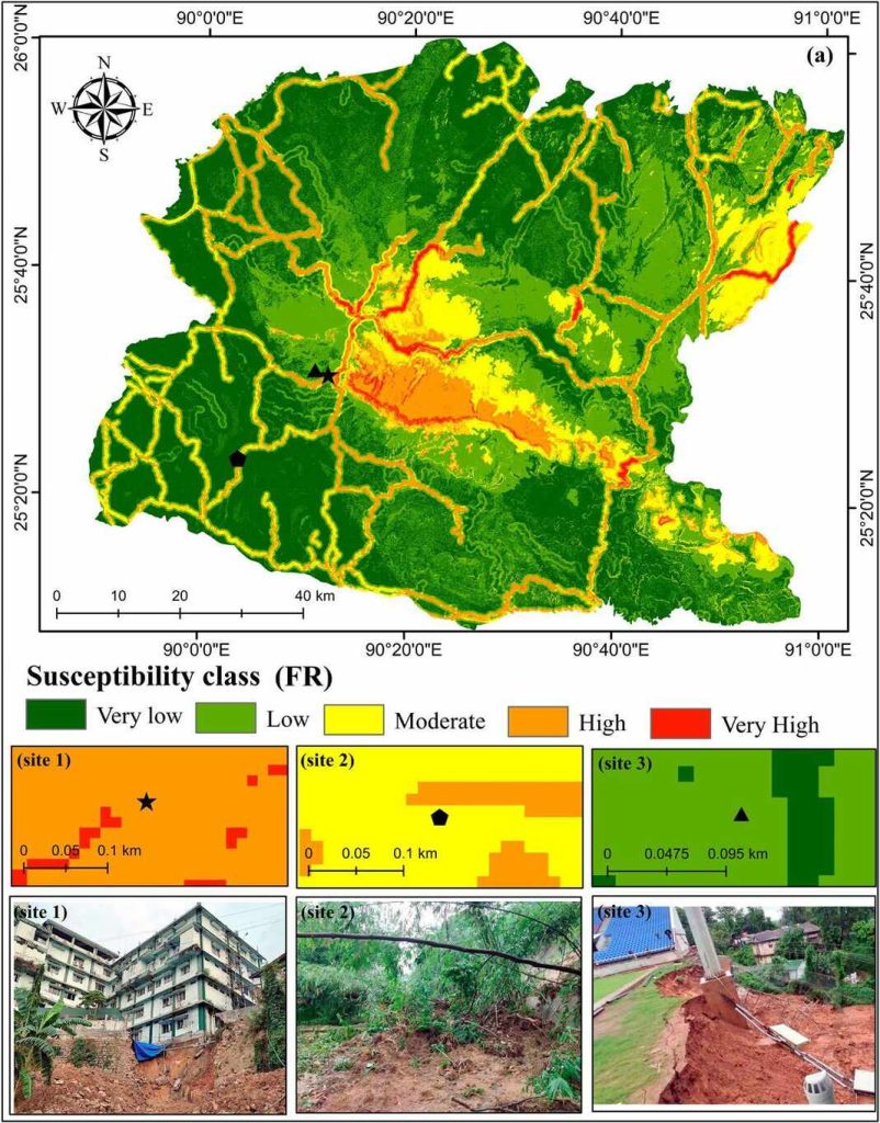
The study, conducted by researchers Naveen Badavath and Smrutirekha Sahoo of the National Institute of Technology (NIT) Meghalaya, mapped landslide susceptibility across the region using advanced modelling techniques. It analyzed 98 recorded landslides from 2000 to 2023 and found that nearly 10% of the Garo Hills falls into high-risk categories, with 3% classified as “very high susceptibility” zones.
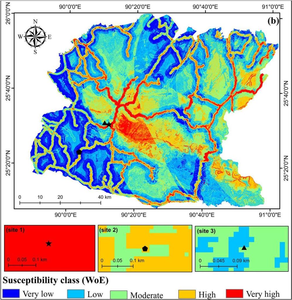
The research, published recently in the Geological Journal, used three different models—Frequency Ratio (FR), Weight of Evidence (WoE), and Shannon Entropy (SE)—to assess the likelihood of landslides across the terrain. The FR method demonstrated the highest predictive accuracy, successfully identifying areas that have already experienced major landslides, including incidents near Tura Civil Hospital, Jebalgre village, and PA Sangma Stadium.
According to the study, the most vulnerable areas are concentrated near steep slopes, roads, and higher elevations, where deforestation and unplanned construction have weakened the land. The study’s findings indicate that human activity has significantly increased the risk in many regions.
“Landslides in the Garo Hills are primarily triggered by heavy rainfall, steep slopes, and human-induced changes such as road construction and deforestation,” the researchers noted. “This study provides crucial data for local authorities and policymakers to develop better hazard mitigation strategies.”
The researchers found that elevation, slope steepness, proximity to roads, and vegetation cover are key factors contributing to landslide risks. High rainfall, which saturates the soil and increases instability, is another major trigger. The study noted that certain geological formations, particularly those with Neogene sedimentary rocks and Quaternary sediments, are more prone to slope failures.
The research team tested their models against recent landslide incidents in the region, and the results confirmed their predictions.
Tura Civil Hospital landslide: The site was classified as a high-risk zone in the study, confirming its vulnerability.
Jebalgre village landslide: The study marked this area as moderately susceptible, in line with the real-life event.
PA Sangma Stadium landslide: This location fell into a moderate to low-risk category, indicating that while landslides are possible, they are less frequent.
These results demonstrate the study’s effectiveness in predicting landslide-prone locations, reinforcing the importance of integrating scientific mapping into regional planning efforts.
Despite the growing threat, landslide mitigation efforts in the Garo Hills remain limited. The study highlights the need for immediate intervention to prevent further damage and loss of life.
“Areas with high susceptibility should have reinforced slope protection measures, proper drainage systems, and regulated land use policies,” the researchers suggested. “Authorities must ensure that construction projects do not disrupt natural drainage patterns, which is a key factor behind increasing landslides.”
The researchers also emphasized the importance of reforestation and soil conservation in reducing landslide risks. Vegetation plays a crucial role in stabilizing slopes, preventing erosion, and absorbing excess water that could otherwise destabilize the soil.
With climate change intensifying extreme weather patterns, experts warn that the frequency and severity of landslides in the Garo Hills could increase in the coming years. Rising temperatures and erratic monsoon patterns could lead to heavier rainfall, further weakening the region’s fragile slopes.
The Meghalaya government has taken some steps to address landslide risks, including early warning systems and slope stabilization projects in select areas. However, the study suggests that a more systematic, data-driven approach is needed to prevent future disasters.
By providing detailed landslide susceptibility maps, the research serves as a crucial tool for disaster management planning, enabling authorities to prioritize at-risk areas and allocate resources effectively.
The Garo Hills, with its rugged terrain and frequent heavy rainfall, has long been prone to landslides. This latest study offers scientific insights that could help prevent future disasters, but its effectiveness depends on how quickly the findings are integrated into policy and action.
Without proactive measures, communities in high-risk zones will continue to face dangerous and unpredictable terrain shifts, threatening lives, infrastructure, and livelihoods in the region.


