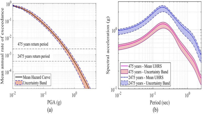
 475-year and (b) 2475-year return period at the surface level")
The researchers estimate that ground shaking in Meghalaya could be up to 1.5 times stronger than what is reflected in India’s current seismic zoning map.
ROOPAK GOSWAMI
Shillong, Jan 19: Seismic hazard in Meghalaya could be more than the possible earthquakes assuming which current building safety standard has been fixed by authorities, according to a new scientific study.
Stated to be the first comprehensive, state-wide probabilistic seismic hazard assessment of Meghalaya, the study raised concerns over seismic safety in one of India’s most earthquake-prone regions.
Conducted by Aakash Kumar and Needhi Kotoky of the National Institute of Technology (NIT), the study indicates that parts of the state—particularly central and northern districts, including areas around Shillong—face a much higher seismic risk than previously estimated.
Based on an analysis of earthquake records spanning more than 160 years (1861–2022) and detailed mapping of active faults, the researchers estimate that ground shaking in Meghalaya could be up to 1.5 times stronger than what is reflected in India’s current seismic zoning map.
To quantify this risk, the study estimates surface-level peak ground acceleration (PGA) across the entire state—a measure of how hard the ground shakes at a specific location during an earthquake.
For buildings designed for a 475-year return period, PGA in Meghalaya could range from 0.50 g to 1.00 g, while critical infrastructure such as hospitals, bridges and dams—designed for rarer 2475-year return period events—could experience PGA levels as high as 0.80 g to 1.80 g.
“This study also estimates surface-level hazards for the entire state of Meghalaya. It calculates surface-level peak ground acceleration (PGA) to be 0.50 g to 1.00 g for a 475-year return period and 0.80 g to 1.80 g for a 2475-year return period,” said Aakash Kumar.
“These values suggest that future earthquakes could generate much stronger ground motion than what many existing structures in Meghalaya are designed to withstand,” the researchers noted.
The study identified major fault systems associated with the Shillong Plateau, including the Oldham, Dawki and Barapani faults, as key contributors to the elevated seismic hazard.
These fault systems have been linked to some of the most destructive earthquakes in the region’s history, including the 1897 Assam earthquake.
It also found that most earthquakes in Meghalaya occur at shallow depths, which typically produce stronger surface shaking, increasing the potential for structural damage—particularly in hill towns such as Shillong, where buildings are often constructed on slopes.
The researchers cautioned that rapid urbanisation, hill cutting, tunnelling, road construction and mining activities are increasing exposure to seismic hazards across the state. Many urban buildings have open ground floors, irregular designs or weak foundations, making them especially vulnerable during strong earthquakes.
The study warned that existing seismic design codes may underestimate actual ground shaking in Meghalaya and called for updated hazard maps that better reflect the state’s complex geology and tectonic setting.
Unlike earlier studies that focused on parts of Northeast India, the research covers the entire state at high spatial resolution, incorporating uncertainty analysis through advanced statistical methods. It provides detailed seismic hazard maps, uniform hazard response spectra for engineering applications and uncertainty bands to support more realistic risk assessment.
The findings are expected to be relevant for urban planning, revision of building safety norms, earthquake-resilient infrastructure design and disaster preparedness in Meghalaya.
The study has been published in the international journal Natural Hazards (2026).


