
By Satyabrat Borah
When the earth gives way high in the roof of the world, the tragedy that unfolds downstream rarely arrives as a gentle warning. A sudden mid week deluge tore through the rugged valleys of Nepal, transforming serene mountain streams into ferocious torrents of mud, ice, and splintered timber. In a matter of hours, a landscape famed for its natural majesty became an arena of profound loss. As body counts rise into the hundreds, with casualties including foreign trekkers and hundreds of Indian nationals unaccounted for, the Himalayan nation finds itself confronting one of the most severe hydrometeorological disasters in its recent history. The catastrophe serves as a stark reminder that while the mountains sustain life across South Asia, they also hold immense, unstable potential for destruction when ecological, geological, and climate dynamics converge.
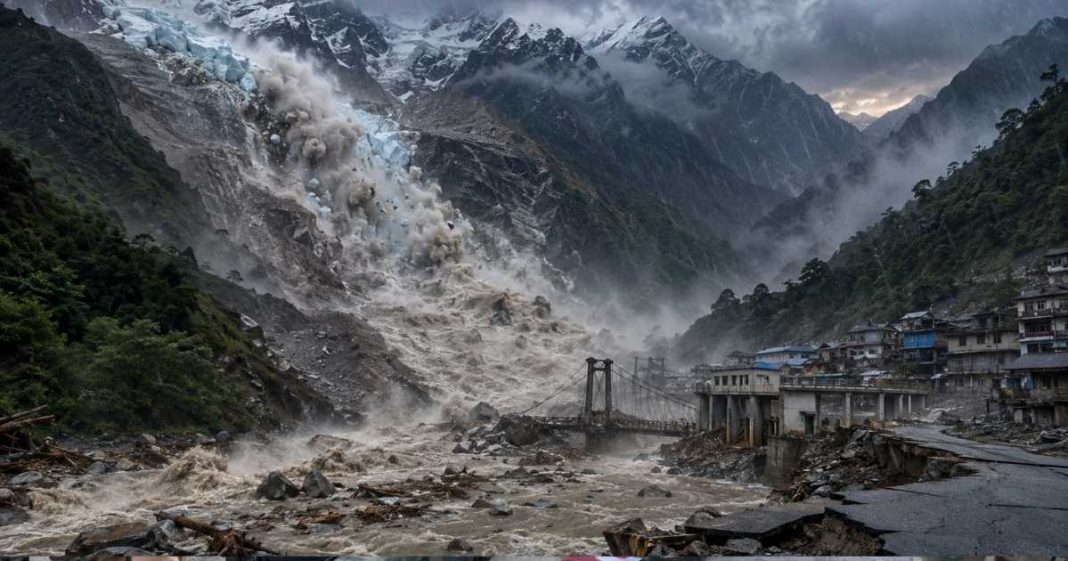
The initial shockwave hit along the steep, vital arterial corridors of the Bhote Koshi and Trishuli rivers. Water levels surged without notice, engulfing entire riverfront settlements, sweeping away markets, and tearing through critical infrastructure. In the early hours following the catastrophe, local accounts and initial reporting focused on the sheer suddenness of the wave. The human toll escalated rapidly. Dozens were confirmed dead in the immediate aftermath, a figure that swiftly surpassed six hundred as emergency services, local residents, and military personnel began digging through meters of silt and boulder strewn debris. Hundreds remain missing, among them construction workers, local villagers, and international tourists who had drawn to the high altitude trails during the trekking season. For families in neighboring India, the anxiety is particularly acute, with scores of citizens untraceable along popular pilgrimage and travel routes that trace the borderlands.
In the immediate wake of such violent mountain floods, early assumptions almost always point toward weather extremes. Given that the disaster struck during the monsoon season, when the broader High Mountain Asia region is frequently impacted by powerful Western Disturbances and heavy monsoonal troughs, initial speculation attributed the event to a massive cloudburst. These extratropical atmospheric systems carry enormous volumes of moisture, which, upon colliding with the formidable vertical relief of the Himalayas, can dump relentless torrents of rain onto restricted catchments within minutes. Similarly, given the region’s intense tectonic activity, seismic triggers were briefly suspected. Preliminary earth observation data began to surface, moving the diagnostic focus from the sky to the cryosphere itself.
Satellite imagery analyzed by space agencies and international geological surveillance networks, including the Indian Space Research Organisation, revealed a different perpetrator. The evidence points to a high altitude cryogenic failure, namely a sudden glacier collapse or a massive ice rock avalanche originating in the high altitude terrain of Tibet, just across the international border. High in these remote catchments, millions of tons of ice and mountain wall sheared away, plunging down near vertical topography into upper river channels. This massive displacement created a cascading disaster mechanism, as the initial impact likely created a temporary natural dam made of ice, soil, and rock, impounding river flow into an unstable barrier lake. When this fragile, temporary dam inevitably failed under the immense hydrostatic pressure, it released a massive wall of liquid mud, ice, and debris downstream, triggering a classic and devastating Glacial Lake Outburst Flood or cryospheric surge.
This mechanism echoes the disastrous events of October 2023 at South Lhonak Lake in Sikkim. There, an upper glacier detachment triggered a catastrophic surge into a glacial lake, breaching its natural moraine dam and releasing a deluge that pulverized major hydroelectric dams downstream and altered the valley topology overnight. Forensic analysis of the Sikkim event later demonstrated that the disaster had been developing for years, driven by subtle thermal degradation, ice melt, and structural weakening of the surrounding slopes. The recent event in Nepal follows this exact, terrifying blueprint, proving that the high Himalayas are experiencing a structural reorganization brought on by accelerated warming.
The physical toll along the affected river basins in Nepal highlights the vulnerability of linear infrastructure built along narrow mountain valleys. The Bhote Koshi and Trishuli corridors represent critical economic lifelines for the nation, serving as primary trade routes connecting Kathmandu to China, as well as hubs for Nepal’s rapidly expanding hydroelectric sector. The surge destroyed dozens of motorable bridges and scores of suspension bridges, effectively severing remote alpine villages from external aid and creating isolated pockets of survivors. Long stretches of highway were simply erased, washed downriver or buried under thick coats of river bed load.
Particularly vulnerable were the nation’s power generation assets. Hydropower developments, which rely on the steep gradients of Himalayan rivers, are situated directly in the firing line of flash floods and mass wasting events. Turbines, diversion dams, intake tunnels, and construction camps were inundated or buried in mud. The destruction knocks out critical national grid capacity in the short term and underscores a fundamental design dilemma, which is how to engineer long term energy infrastructure in a landscape where the hydrologic baselines are rapidly shifting under climate pressure.
Compounding the crisis is the lingering threat of secondary disasters. While the main flood wave has receded, the physical geometry of the affected valleys has been dangerously altered. Enormous volumes of loose, saturated sediment now lie piled in tributary junctions and narrow gorges upstream. With the monsoon season ongoing, further precipitation can easily trigger massive mudflows or create new, unstable debris dams. Authorities have issued repeated warnings to downstream populations, keeping communities along the lower reaches of the Trishuli on high alert as rescue workers navigate treacherous, shifting terrain.
The challenge of monitoring and predicting such events remains one of the most formidable hurdles in alpine science. The Hindu Kush Himalaya region hosts nearly fifteen thousand glaciers and around seven thousand five hundred glacial lakes. Remote sensing technology has advanced remarkably, offering high resolution optical and radar coverage of remote ice bodies, but satellite imagery alone cannot replace ground truth. A glacial lake may appear stable from an orbital perspective, while its internal ice core or structural dam undergoes unseen structural failure. Ground based scientific expeditions are necessary to assess the real time physical parameters of these high altitude features. Such expeditions are logistically demanding, prohibitively expensive, and constrained to a narrow operational window, typically between July and September, when weather conditions permit high altitude travel.
Even when monitoring systems identify an impending risk, the translation of scientific data into actionable, life saving early warnings presents a profound social challenge. Predicting the precise moment a glacier will collapse or an ice rock avalanche will breach a natural dam remains outside current forecasting precision. False alarms or vague high altitude risk warnings can generate operational fatigue or panic among riverine communities. Many residents in these mountain valleys remain in high risk zones because of economic necessity, ancestral ties, or a lack of viable land elsewhere. In such contexts, early warning systems must be paired with clear evacuation protocols, safe land allocations, and resilient community infrastructure if they are to save lives.
Past immediate search, rescue, and humanitarian relief efforts, the tragedy in Nepal demands a systemic re evaluation of how mountain regions are developed. Climate change is undeniably destabilizing the cryogenic envelope of the Himalayas, accelerating glacier retreat and increasing the frequency of compound extreme events. Attributing these catastrophes entirely to natural forces ignores the human choices that amplify their impact. The rapid expansion of roads, unregulated urban settlements, and large scale engineering projects in ecologically sensitive valleys significantly elevates exposure and vulnerability.
Addressing these challenges requires a shift from reactive disaster response to proactive risk governance. Governments across the Himalayan belt must strictly enforce land use planning and building codes that account for dynamic multi hazard profiles. Known high risk zones, such as ancient floodplains and unstable slope bases, should be restricted from permanent settlement and critical construction. Infrastructure development must integrate advanced cryospheric monitoring data directly into project design, site selection, and risk assessments. Investing in long term observational networks, combining high frequency satellite telemetry with automated river gauges and community level warning sensors, can provide crucial lead time when high altitude failures occur.
A natural hazard becomes a disaster when it collides with human vulnerability. Tragedies like the flood along the Bhote Koshi are rarely the product of unpredictable fate alone. They are the cumulative result of systemic vulnerabilities, unplanned development, and neglected environmental realities. The melting ice and shifting mountains of the Himalayas are delivering a clear message. To prevent future loss of life, planning strategies must adapt to the ecological limits of a changing landscape, ensuring that development in these fragile valleys works with nature rather than against it.